
The Imperial Overcoat
In 1901, Vilkaviskis was not an independent town, but a cog in the massive Russian Empire.
-
The Language of Power: That while the residents spoke Yiddish or Lithuanian, the "official" world was Russian. All permits, court cases, and even the labels on medicine were in Cyrillic.
-
The Ranks: Note the prestige of the officials like Petr Lermontov (Marshal of Nobility) and Police Chief Stankevich. They represented the "Tsar’s shadow" over the town.
The Gateway Economy (Trade & Border)
Vilkaviskis was so prosperous compared to other towns.
-
The Railway Pulse: Describe the "Kybartai Railway Colony."It was a brand-new, modern world of steel and steam, connecting the town to the fashion houses of Paris and the factories of Berlin.
The Merchant Interface: Highlight that the Jewish community, such as the families running the Bernheim & Co. trading house, acted as the vital bridge between the Russian and German empires.
The Social Mosaic (The People)
This is where you bring in that "wider picture" of the non-Jewish middle class.
-
The Clergy and Teachers: Lithuanian Catholic Church and the new "People’s Schools" as the intellectual heart of the Lithuanian population.
-
The State Rabbi: Mention Itsek-Meyer Freidberg, who held the official government authority to record the births and deaths of the Jewish community.
-
The Professionals: Include the doctors and pharmacists like Dr. Gintovt, who served everyone regardless of their language or faith
-
The Landscape (The Land and Forests)
Physically, the town was defined by its relationship with the earth and water. Situated at the junction of the Šešupė and Veidra rivers, the land was exceptionally fertile.
-
The Green Belt: The surrounding estates, or Folvarks, such as Paežeriai, were the economic engines of the countryside. These estates featured massive state-run nurseries and orchards.
-
The Great Forest: To the west lay thousands of acres of state-managed forest, a dark green wall that provided the timber for the town’s construction and the fuel for its fires.

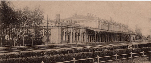
Vilkaviskis at the turn of the 20th Century the wider picture
Up till now I concentrated on what we know of the Jewish Community but the Jews were only a part of the larger community. Vilkaviskis had been part of the Russian Empire for almost 100 years.
A Town Under the Tsar
To understand Vilkaviškis in 1901 is to understand a town wearing a Russian "overcoat." While the heart of the town beat with Yiddish and Lithuanian, the skeletal structure was Imperial Russian. Every official document, from a birth certificate signed by the State Rabbi Itsek-Meyer Freidberg to a land permit for a nursery, was processed through a rigid hierarchy of Russian officials. The "Power Players"—men like the District Marshal of Nobility Petr Lermontov and Police Chief Stankevich—ensured that even in this remote borderland, the authority of St. Petersburg was felt in every shop and on every street corner.


This 1914 map shows Vilkaviškis at its absolute peak of Imperial development. You can see the distinct "bones" of the town:
-
The Main Square: This was the heart of the Jewish merchant life we saw in the 1901 directory.
-
The Cathedral & Synagogue: You can see how these massive structures dominated the skyline, marking the Lithuanian and Jewish centers of the town.
-
The River Veidra & Šešupė: The exact curve of these rivers is vital. It shows which parts of the town were the "green belts" where nurseries and gardens would have thrived in the rich, silty soil.
The "Non-Jewish" Infrastructure
We can now see the physical locations of the "Power Players" we found in the 1901 book:
-
The Government Buildings: The offices of the District Police Chief (Stankevich) and the Marshal of Nobility (Lermontov).
-
The Barracks: Since this is 1914, the Russian military presence is much more visible on the map. You can see the areas designated for the cavalry and infantry that patrolled the border.
-
The Industrial Edge: The mills and small factories that formed the beginning of that Lithuanian middle class we discussed.
The Strategic View
The map was created right as World War I was beginning. It shows the town not just as a home, but as a strategic military objective. The roads leading to the Prussian border (toward Kybartai/Eydtkuhnen) are the most prominent features. In 1914, these weren't just trade routes anymore; they were the veins through which the Russian army moved toward the front.
Below you will see the aspects of Jewish life in Vilkaviskis during the Russian period